Melting Greenland
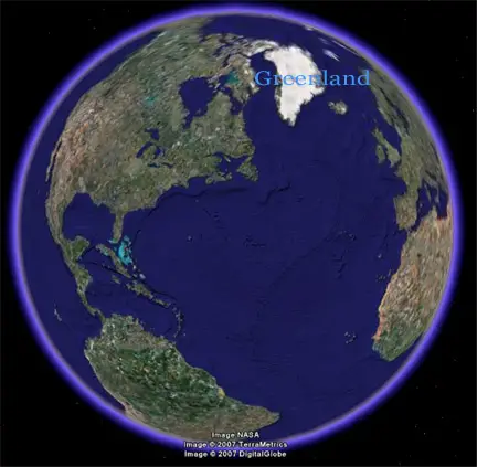
Greenland (Greenlandic: “Kalaallit Nunaat”, is a self-governing Danish province located between the Arctic and Atlantic Oceans. Though geographically and ethnically an Arctic island nation associated with the continent of North America, politically and historically Greenland is closely tied to Europe, specifically Iceland, Norway and Denmark. It is the largest island in the world that is not also considered a continent.

Melting Greenland Icesheet
The Greenland Ice Sheet extends from 60º to 80º N, and covers an area of 1.7 million square km. With an average thickness of 1600 m, it has a total volume of about 3 million cubic km (about one ninth of the volume of the Antarctic Ice Sheet) – roughly equivalent to a sea-level rise of 7 m. It comprises a northern dome and a southern dome, with maximum surface elevations of approximately 3200 m and 2850 m respectively, linked by a long saddle with elevations around 2500 m. Bedrock beneath the central part of the ice sheet is remarkably flat and close to sea level, but the ice sheet is fringed almost completely by coastal mountains through which it is drained by many glaciers.
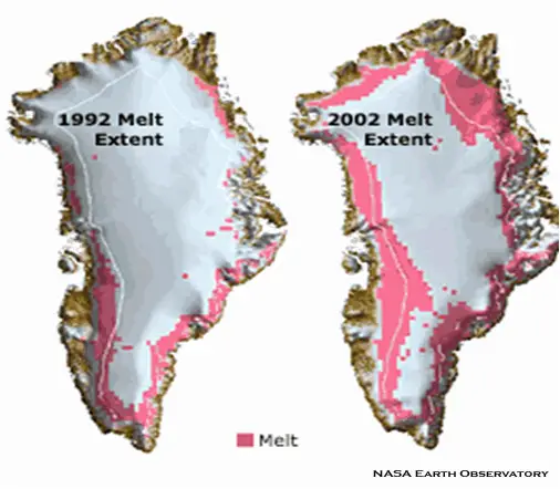
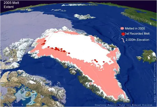
Greenland’s climate is strongly affected by its proximity to other land masses and to the North Atlantic, leading to a proportionately higher rate of exchange of water between ice sheet and ocean than in Antarctica. Summer melting occurs over about half of the ice-sheet surface, with much of the meltwater flowing into the sea, either along channels cut into the ice surface or by draining to the bed via crevasses. The average snow accumulation rate is more than double that of Antarctica.
There are only a few ice shelves and, where they do exist, basal melting rates are much higher than in Antarctica – they can exceed 10 m per year. This gives an indication of the potential effect warmer Southern Ocean temperatures would have on Antarctic ice shelves. The melting Greenland Ice Sheet is particularly important to the study of sea-level change in a warming climate for two reasons.
First, it is likely to respond rapidly to warmer temperatures because surface melting already occurs widely. This means that small increases in air temperatures result in large inland migrations of summer melt zones up the gentle slopes of interior parts of the ice sheet. Increasing summer melt reduces ice-sheet volume directly, by drainage into the ocean, and indirectly, by lubricating the base of outlet glaciers and increasing their total ice discharge into the ocean. Second, melting Greenland provides a picture of Antarctic conditions if climate warms enough to weaken or remove key ice shelves. Recent observations in Antarctica confirm the early predictions of substantial glacier acceleration following ice-shelf removal.
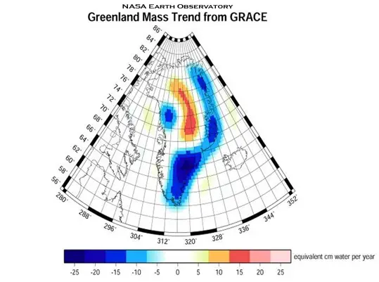
The weight of the massive melting Greenland ice sheet has depressed the central land area to form a basin lying more than 300 m (1,000 ft) below sea level. However, from the image below we can see the loss in the weight of the melting Greenland Ice Sheet between 2003 and 2005. The low coastal areas (blue) lost three times as much ice per year from increased melting and icebergs than the high elevation areas (red/orange) that gained ice due to excess snowfall.

Greenland is now losing 20 percent more mass than it receives from new snowfall each year. Ice sheets are thick, broad masses of ice formed mainly from compaction of snow. They spread under their own weight, transferring mass towards their margins where it is lost primarily by runoff of surface melt water or by calving of icebergs into marginal seas or lakes.

Ice sheets flow by deformation within the ice or melt water-lubricated sliding over materials beneath. The complete melting of the Greenland ice sheet would result in a sea-level rise of about 7 metres (23 feet).
After years of moving at a relatively stable speed, Helheim Glacier in southern Greenland has dramatically accelerated. Additional melt water lubricates the river of ice making their downhill movement easier and faster (see the section on Moulins, for more on this fascinating subject). According to a University of California-Santa Cruz study, Helheim Glacier’s peak rate of flow has increased from 8 km per year in 2000 to 11 km per year in 2005. In addition to flowing more rapidly the glacier thinned by 40 metres between 2001 and 2003. The calving front of the glacier (the area where the ice breaks away and falls into the ocean) has retreated by approximately 5 km.

Importance of Ice and Snow Cover
Currently, ice permanently covers 10% of the land surface, with only a tiny fraction occurring outside Antarctica and Greenland. Ice also covers approximately 7% of the oceans in the annual mean. In midwinter, snow covers approximately 49% of the land surface in the Northern Hemishpere.
An important property of snow and ice is its high surface albedo. Because up to 90% of the incident solar radiation is reflected by snow and ice surfaces, while only about 10% is reflected by the open ocean or forested lands, changes in snow and ice cover are important feedback mechanisms in climate change. In addition, snow and ice are effective insulators. Seasonally frozen ground is more extensive than snow cover, and its presence is important for energy and moisture fluxes. Therefore, frozen surfaces play important roles in energy and climate processes.
Around Melting Greenland
In September 2003, scientists from the United States and Canada announced that the largest ice shelf in the Arctic had broken up. The Ward Hunt ice shelf to the north of Canada’s Ellesmere Island split into two main parts, with other large blocks of ice also pulling away from the main sections. Evidence continues to emerge that average temperatures in the Arctic are rising even more rapidly than the global average.
Satellite data indicate that the rate of surface temperature increase over the last 20 years was eight times the global average over the last 100 years. Studies report that the extent of Arctic sea ice has shrunk by 7.4 per cent over the past 25 years, with record-low coverage in September 2002.
An analysis of 30 years of satellite data suggests that the loss of Arctic sea ice is also accelerating. There are projections that much of the sea ice, until now thought to be permanent, will melt during the summer by the end of this century if the current trend in global warming continues. This will have major direct impacts on indigenous people and Arctic wildlife such as polar bears and seals, and will also open the region to increased development pressure as access by sea to valuable natural resources becomes easier.
The global impacts may also be significant as absorption of solar radiation increases, and could lead to changes in the world ocean circulation. The positive feedbacks involved here are that once the melting Greenland ice sheet gets thinner, temperatures are higher, increasing the melting and causing more precipitation to fall as rain rather than snow. This also lowers the albedo of the exposed ice-free land causing a local climatic warming; and the cycle speeds up and continues, where surface melt water accelerates ice flow.
