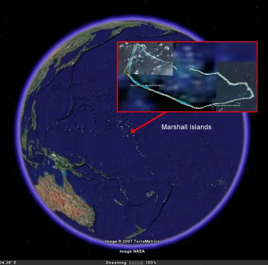
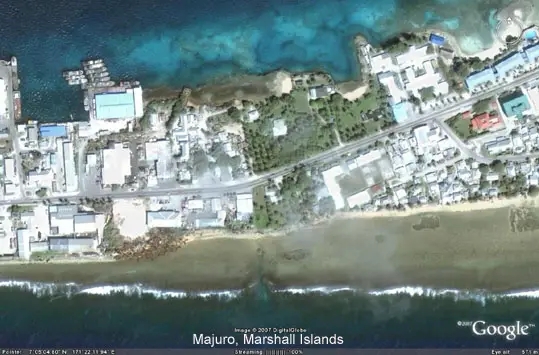
Majuro atoll, capital of the Marshall Islands, is the most developed atoll in the Marshalls with a population of nearly 30,000. Majuro, like many atolls, consists of extremely narrow land masses which allow a person to walk from the lagoon side to the ocean side within minutes. At some points the island is narrow enough to throw a rock from one side to the other. Most of the roadway from Delap to Laura is a single two lane paved road with houses on either side.
Majuro offers visitors diving and fishing, a cultural museum, a variety of cuisine, entertaining nightlife and is often a ‘home base’ while visiting the outer islands. Day trips can be taken to neighboring Arno Atoll for diving or fishing.

Capital of the Marshall Islands
The Marshall Islands are a small island state in the North Pacific. These islands are a collection of 1,225 islands and islets of which only five are single islands. The rest are grouped into 29 coral atolls which together make up more than one-tenth of all the atolls in the world. They resemble strings of pearls in a blue ocean backdrop, which is why they are referred to as the ‘Pearl of The Pacific’. They lie in two parallel chains known as Sunrise and Sunset (Ratak and Ralik) and in true atoll form, they are narrow and low and encircle large central lagoons. All the islands have white sandy beaches, tall palms. Of the 29 atolls, 27 are accessible by small plane.
The Marshall Islands were settled by Micronesian people approximately 2,000 years before the birth of Christ. They were “discovered” by the Spanish. Named by John Marshall, a passing British explorer, they were later colonized by the Germans, invaded and re-colonized by the Japanese and re-invaded and entrusted to the United States. They achieved independence in 1986.

The Economy
The economy of the Marshall Islands is based on rent paid by the U.S. government for the use of Kwajalein and other atolls as weapons-testing facilities. Nuclear testing started in 1946 on Bikini atoll, the oldest site of human habitation in Micronesia. The debris from that site will be dangerous to humans for 50,000 years.
Majuro atoll in the capital, 95 percent of the food is imported. The levels of diabetes, hypertension and youth blindness are among the highest in the world. The people no longer cultivate and eat their traditional foods, and they rarely fish. Copra (coconut oil) is one of the main exports in the Marshall Islands, and receives copra shipments from most of the smaller populated atolls surrounding the area.
The lagoon in Majuro atoll said to be polluted from human wastes and drift-netting has ravaged the deep water fish stocks. A major PCB spill occurred in 1989 and apparently still remains a threat to the water supply. There are no effective consumer laws to regulate the excesses of the marketplace; consumers are uninformed and have no access to redress.
Climate Issues
Many nations within the Asia Pacific region already struggle to cope with the current climate variability which exposes their populations to tropical cyclones, rainfall extremes, frequent droughts and extreme tides.
The Lowy Institute’s report on Climate Change and Security articulated this very clearly. “For a handful of small, low-lying Pacific nations, climate change is the ultimate security threat, since rising sea-levels will eventually make their countries uninhabitable.”
Whilst these islands contribute the least to global greenhouse gas emissions, emitting an estimated 0.06 percent of the world’s emissions, the Intergovernmental Panel on Climate Change (IPCC) has declared them three times more at risk to climate change than countries of the global north.
The logical conclusion is that relocation is therefore inevitable and many people in the region are predicted to become climate change refugees, forced to leave their homes due to untenable environmental impacts. In parts of Fiji and Tuvalu,increased salinity is forcing families to grow their root crops in metal buckets instead of in the ground. In Majuro atoll, the capital of the Marshall Islands, sea walls have been constructed to try to protect existing infrastructure and halt the impact of erosion.
The Majuro Atoll in the Pacific Marshall Islands is projected to lose 80% of its land with a 20- inch (0.5m) rise in sea level. Coral reefs, which protect many of these islands, will be submerged, subjecting to heightened storm surges and disrupted coastal ecosystems. Many of the tropical islands across the Pacific depend heavily on island-hopping tourism scuba diving and snorkelling are the main draws, along with sport fishing. But the underwater scenery is threatened by climate and ocean changes that affect the region’s living coral reefs.

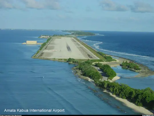
The Amata Kabua International Airport on Majuro atoll has a 7,897-foot asphalt runway, on the road from the capital, Majuro, to Laura. It was constructed by building a causeway across several small islands. It is just wide enough for the two-lane road and the runway, the ocean on one side, the lagoon on the other. Drains on either side of the runway collect and store fresh rainwater. This runway, only six feet above the ocean, is a major source of fresh drinking water as well as of tourism and trade, and it’s vital to the life of the Marshallese.
Sea walls have been built on both sides of the road to the airport and the runway itself, and are now being continued toward Laura. From time to time the ocean washes across this road and during the last decade, the island of Majuro has lost up to 20 per cent of its beachfront. Locals believe that the powerful storms and sweeping high tides are causing most of the coastal erosion. Majuro has built up sea walls to prevent further erosion, even using garbage imported from the United States. Land is scarce, however, and the walls need constant rebuilding. According to government officials, building and maintaining effective sea walls will cost more than the Marshall Islands’ annual budget.
